Hiking in Dagestan - "The Land of Mountains"
From 25 000₽ per person
Description
Type: Multi-day activity
* Hiking in the mountains of Dagestan is a stunningly beautiful world of snow–capped rocky mountains, mysterious caves and steep canyons through which rushing rivers flow. Among other things, these are dense relict forests combined with endless alpine meadows, high-altitude stone villages and medieval fortresses, like ancient guardians guarding the peace of the valleys. Dagestan literally translates as "the land of mountains," and for good reason: the republic has more than 30 peaks above 4,000 meters in height. The local people are more than thirty nationalities inhabiting these blessed lands and reverently honoring their traditions from the Caspian Sea to the mountains of the Main Range. Dagestan is waiting for you!
During the 9 days of our tour, we will see:
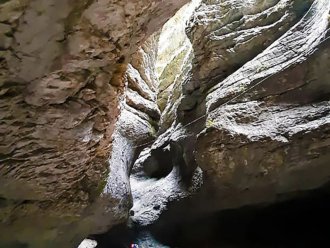
- Amazing underground Saltinsky Waterfall
- The longest tunnel in Russia in Gimri
- Derbent, the oldest city in the Russian Federation
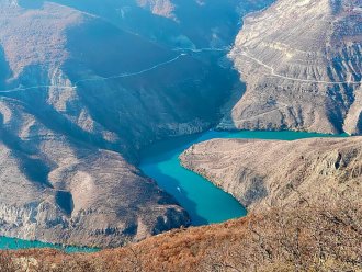
- The deepest European canyon is the Sulak Canyon
- Karadakh gorge
- Chirkey reservoir
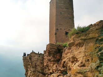
- Ancient Dagestan medieval fortresses - Goor, Gamsutl and Kahib
Duration - 9 days (8 nights)
Mileage: 80 km
The next dates are in 2025:
02.05 - 10.05
24.09 - 02.10
Available languages
Group type
Age restrictions
Training level
Transfer
day 01
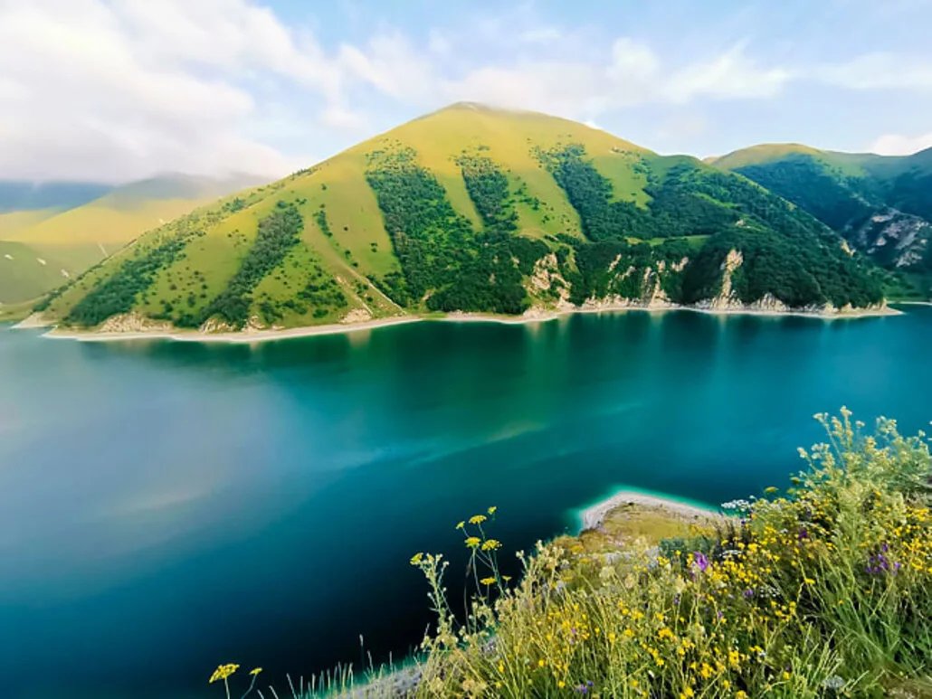
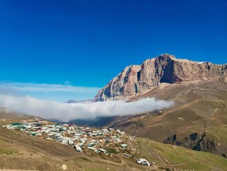
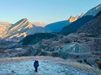
Makhachkala. Sulak Canyon. Chirkeyskoye reservoir. Aul Kahib.
Type of accommodation:Tent
We will meet at the Makhachkala railway station near the entrance at 8 a.m., I strongly recommend that you arrive in advance and spend the night in Makhachkala so as not to be late for the meeting. After the meeting, we take a registered bus towards our pedestrian part. The first of the attractions on our way is a huge natural canyon in the picturesque Sulak river valley, which reaches a depth of almost two kilometers. The huge cliffs plunging steeply into the turquoise waters of the canyon create their own inimitable atmosphere of unreality, attracting tourists. We will sit on the slopes and admire the grandiose spectacle, after which we will find the Chirkey reservoir, created by the dam of the same name, one of the most beautiful hydraulic structures in the world. After that, we will pass through the longest tunnel in the Russian Federation - Gimrinsky, at the exit of which we will admire the Irganai reservoir. And in the evening, already tired from moving, we will arrive at the mountain village of Kahib, next to which we will set up our camp.

day 02
Old Kahib village. Goor village.
Type of accommodation:Tent
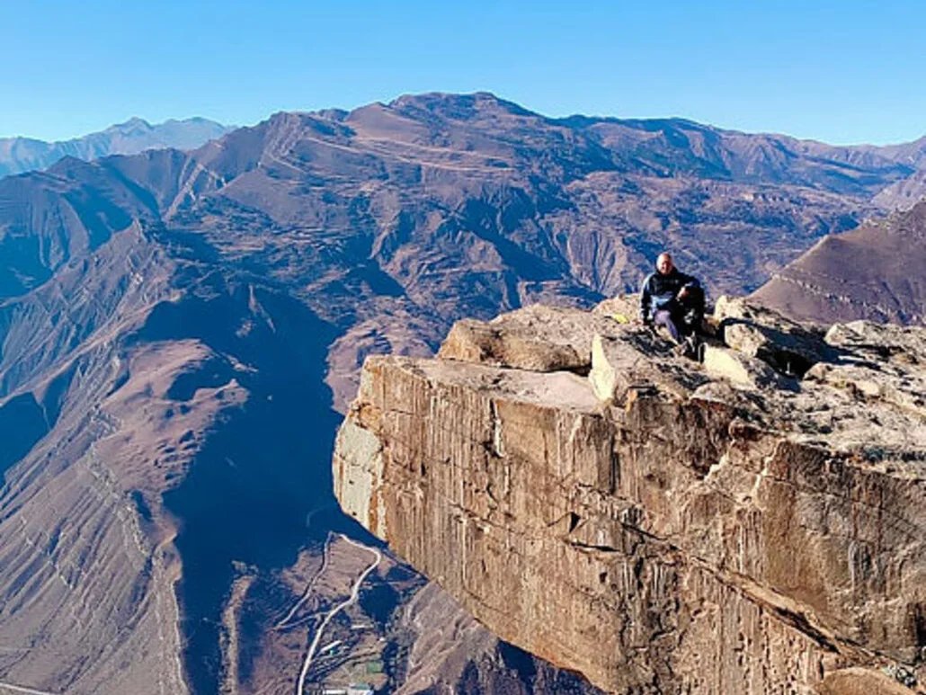
After waking up in the morning and having breakfast, we set off light to explore the ancient villages of Old Kahib and Goor. Both of them were founded in the 8th century, fulfilling a very tangible function of protecting ancient trade routes. Huge towers flank solid stone walls that cover the ancient streets of the settlement from all sides. Old Kahib and Goor, while life was bubbling in them, were famous for skilled craftsmen of forging and carving, but gradually life here faded away, the inhabitants moved across the river, leaving the villages to the inexorable time. After walking along the ancient streets, we will go to a cafe on the outskirts, where we will taste local cuisine, eat Dagestani miracles and drink fragrant herbal tea, after which we will visit the local "Troll Language", taking a couple of unforgettable photos on a stone ledge.
Distance: 12 km
Up: 700 meters
Down - 700 meters

day 03
The Kahibtyar River. Tabazhatlimer Pass. The Zgurtlar River.
Type of accommodation:Tent
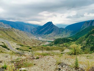
We are on our way, and today we have to overcome the Tabazhatlimer pass with a height of 2020 meters, separating the valley of the Kakhibtlar River from the Zgurtlar River. From the pass there are beautiful panoramas of the surrounding mountains, after which we descend, where we will settle on the high banks of a noisy river.
Distance: 13 km
Up: 600 meters
Down - 500 meters
day 04
Aul Ziourib. Gogotl village.
Type of accommodation:Tent
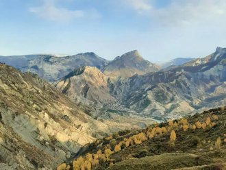
We go further, and after crossing the wide valley of the Zgurtlar River, we will see the mountain village of Ziurib, which has still preserved local traditions and way of life. The branching streets of Ziouriba will lead us to an observation deck, from where we will admire the nearby peak of Sedlo, to the foot of which we will head. After skirting several canyons along the way, we will come to Gogotl, another village lying at an altitude of 1,750 meters, where antiquity and modernity came together in an unequal battle, gradually displacing one another. We are going to spend our night on the outskirts of Gogotl.
Distance: 15 km
Up: 300 meters
Down - 500 meters
day 05
Gogotl. Gagomeer Pass. Gadachi Gorge.
Type of accommodation:Tent
We pack up the camp and set off through Gogotl village to our next destination. Settlements on the site of this village have been known since the Neolithic period, and even in the Middle Ages, people constantly settled in these fertile lands, supporting life in the village. Gogotl is surrounded on almost all sides by artificial terraces that served as vegetable gardens and gardens for local residents. After passing them, we will enjoy beautiful views of the Avar Koisu valley and the large Chinameyr plateau lying on it. After admiring and relaxing, we climb the Gagomer pass, after which we can only drop the altitude, descending into the Gadachi gorge and settling down on the banks of the stream of the same name.
Distance: 10 km
Up: 300 meters
Down - 800 meters
day 06
Koroda village. The Quarto Gorge. Karadakh Gorge
Type of accommodation:Tent
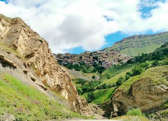
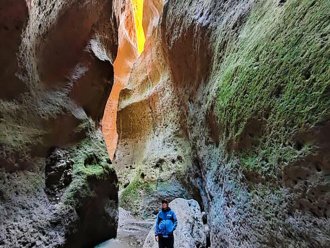
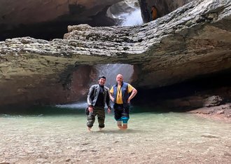
Our journey continues, and after walking along the Gadachi River, we will enter the valley of the Kuiada River, where one of the most ancient villages of Dagestan, Koroda, is located. The old settlement, built on steep cliffs, which once served as a fortress, has now been abandoned by residents who have moved to more easily accessible places at the foot. After Koroda, the path will lead us to the Kvartakh River, which formed the gorge of the same name. It was this river that for thousands of years has gnawed out the famous Karadakh gorge in the local rocks, our next tourist location. The gorge is famous for its dimensions: at its narrowest point, its width is no more than two meters, while its depth reaches almost one hundred and seventy meters. After admiring the amazing place, we continue along the gorge. We still have to work a little harder until we reach the alpika, where we will camp for the night.
Distance: 13 km
Up: 700 meters
Down - 300 meters
day 07
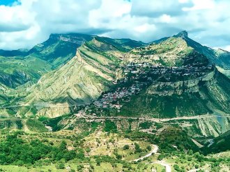
The Gunib plateau. Upper Gunib. Mayak Mountain.
Type of accommodation:Tent
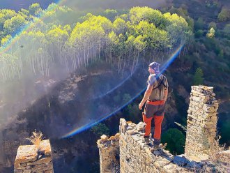
In front of us lies a huge stone island with towering sheer cliffs - the Gunib plateau, which we have to climb today. Following the trail to Mount Kaligheg, one of the peaks of the plateau, we will enter the Kara Kaisu Valley through the Imperial Tunnel. Beyond the tunnel begins the Upper Gunib Park, one of the main business cards of Dagestan. The two-hundred-year-old Gunib fortress, the Old Gate along the way, is a must-visit, and then, as if floating in the clouds, the village of Gunib stretches along the slopes of the cliff to a height of almost 700 meters. If you wish, we will run light to the 2,350-meter-high Lighthouse peak, the highest on the plateau, which offers stunning views of the Main Caucasian Ridge.
Distance: 10 km
Up: 900 meters
Down - 200 meters
day 08
The average Gunib. Saltinsky waterfall. Gamsutl. Derbent.
Type of accommodation:Motel
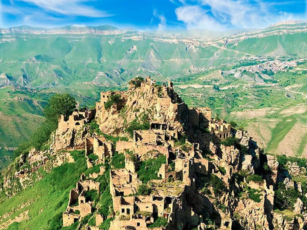
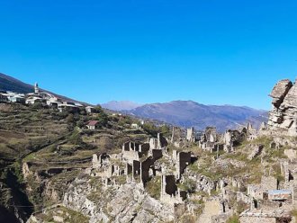
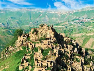
We are waiting for a short transfer to the village of Sredny Gunib, teeming with cheerful tourists. After passing through the forest, we will come to a small observation deck, from where you can admire the streets of a mountain village and a pretty mosque surrounded by impressive Caucasian landscapes. On the way, we will take a look at the Gunibsky waterfall hidden in the rocks, after which, going out to the village, we will settle in one of the cozy cafes with colorful views of the Kara Koysu valley lying below us. After dinner, we load into a custom-made bus and go to Derbent, along the way stopping at another amazing local landmark - the underground Saltinsky waterfall, cut through a 20-meter thick earth by an indefatigable river. After the waterfall, another amazing location awaits us - the abandoned village of Gamsutl, reminiscent of the abandoned Inca cities in the Andes. Gamsutl lies at an altitude of one and a half kilometers above sea level, occupying literally every meter of the useful area of the rock that serves as the base, often using the rock itself as a natural wall, which creates the illusion that Gamsutl grows out of a stone mountain. Gradually, our route is coming to an end, and we will have to settle in Derbent in a cozy eco-hotel.
Distance: 5 km
day 09
Derbent
Type of accommodation:Not included
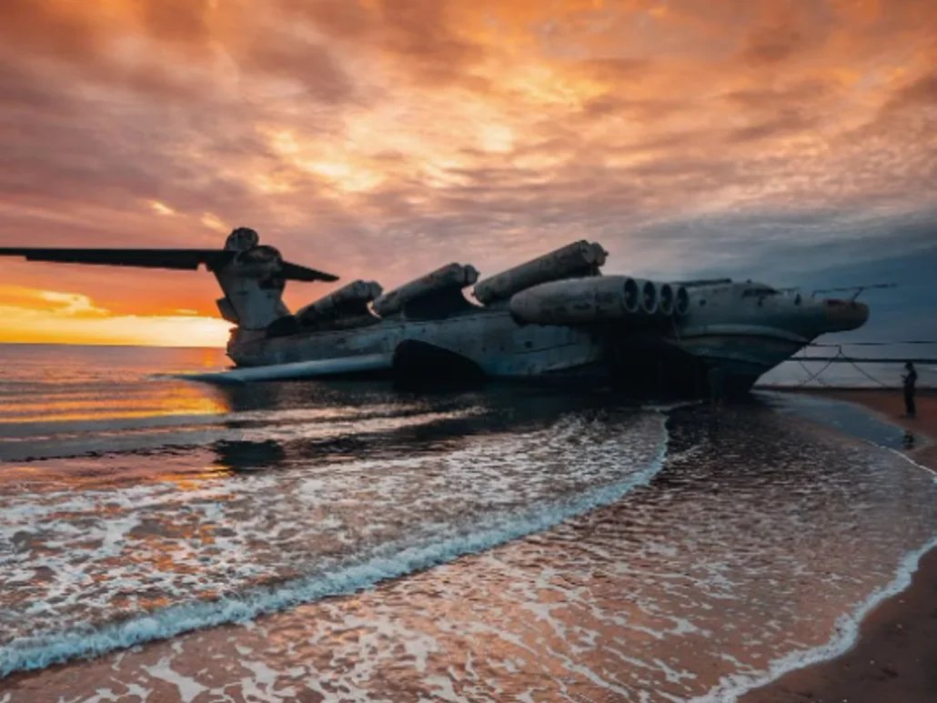
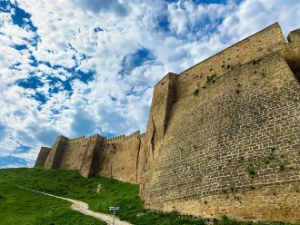
Derbent is an ancient city dating back to the third millennium BC. There is a lot to see and take a walk here: the Narynkala fortress, the quaint streets of the old town, more than 10 museums, the pride of a bygone era, the Lun ekranoplane, the bustling city bazaar and, of course, the Caspian Sea. We are saying goodbye to you in Derbent, see you later!
Details
Included
Excluded
Starting point
* Meeting place of the group: Makhachkala 8:00Finish point
* The hike ends: Derbent 12:00Popular tickets
All tickets
Идем в поход!
Organizer
Походы в горы с инструктором по России и за рубежом.